|

FORT LIPANTITLÁN
from The New Handbook Of Texas
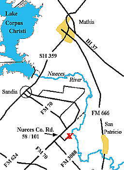
Fort Lipantitlán (meaning "Lipan land") was conceived about 1825
by José M. J. Carbajal. The site, now in northwestern Nueces County,
was that of camping grounds of the Lipan Apache Indians on the west bank
of the Nueces River about three miles upstream from the old town of San Patricio,
which is on the east side of the river. At the site a number of ancient trails
beaten by game animals, Indians, and explorers crossed. An old presidio was
also reportedly there as early as 1734 but had completely vanished. Mexican
general Manuel
de Mier y Terán
, acting on the orders to restrict Anglo immigration into Texas, commissioned
the fort and placed Capt. Enrique Villareal in command. He served until 1835,
when he was relieved by Capt. Nicolás Rodríguez.
Author John Linn wrote, "The fort was a simple embankment of earth,
lined within by fence-rails to hold the dirt in place, and would have answered
tolerably well, perhaps, for a second-rate hog pen." After its construction
it was garrisoned with from eighty to 120 men; however, many times the complement
was much less. Each of the four parapets was designed for one cannon, but
it is doubtful if the fort was ever fully armed. Evidently several buildings
and at least one barracks were built surrounding the embankments. James McGloin,
in his account of the battle of Lipantitlán (November 4, 1835), makes
reference to burning several houses, including a barracks.
The Mexican armies, coming north by land out of Mexico, headed
to Goliad, Refugio, and East Texas during the Texas Revolution and crossed
the Nueces at either the De Leon Crossing at the fort or Paso de Santa Margarita
near San Patricio. During this period Mexican troops were in almost constant
occupancy of the fort. Captain Rodríguez was in command of the Mexican
forces when Capt. Ira J. Westover and a force of about seventy Texans defeated
the Mexicans on November 4, 1835. Since the Texans did not occupy the fort
after their victory, Mexican forces continued to use the old fort on occasion.
Fort Lipantitlán played an important role in the years immediately
after the war, when Federalist forces under Gen. Antonio Canales sought refuge
on the Nueces River to regroup and to seek assistance from Americans. Gen.
James Davis repulsed Mexican troops under Canales at Lipantitlán on
July 7, 1842. After the Mexican War put an end to Mexican armies in Texas,
Lipantitlán was abandoned and grew up in brush.
In the mid-1980s digs on private land uncovered a number of artifacts
in a rather large camp adjacent to the old fort where families and army women
lived. A population of 300 or more in the camp is considered likely. The
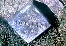
site of the old fort is a state park, but no traces of the earthen embankments
remain. The archeological digs confirmed Indian presence before the Spanish
and Mexican eras, as well as occupancy by Texas forces in 1842. Aboriginal
ceramics, Indian artifacts, personal items, all types of military buttons
and ordnance (Spanish, Mexican, and Texan), money, and miscellaneous hardware
were among the hundreds of artifacts recovered.
BIBLIOGRAPHY: Eugene C. Barker, ed., The Austin Papers (3 vols.,
Washington: GPO, 1924-28). William Campbell Binkley, ed., Official Correspondence
of the Texan Revolution, 1835-1836 (2 vols., New York: Appleton-Century,
1936). Bethel Coopwood, "The Route of Cabeza de Vaca," Quarterly of the Texas
State Historical Association 3 (October 1899, January, April 1900). Charles
Adams Gulick, Jr., Harriet Smither, et al., eds., The Papers of Mirabeau
Buonaparte Lamar (6 vols., Austin: Texas State Library, 1920-27; rpt., Austin:
Pemberton Press, 1968). Hobart Huson, Refugio: A Comprehensive History of
Refugio County from Aboriginal Times to 1953 (2 vols., Woodsboro, Texas:
Rooke Foundation, 1953, 1955). Hobart Huson, Captain Philip Dimmitt's Commandancy
of Goliad, 1835-1836 (Austin: Von Boeckmann-Jones, 1974). Hobart Huson, Souvenir
Program, Refugio County Centennial Celebration (Refugio: Refugio Timely Remarks,
1936?). John J. Linn, Reminiscences of Fifty Years in Texas (New York: Sadlier,
1883; 2d ed., Austin: Steck, 1935; rpt., Austin: State House, 1986). Joseph
Milton Nance, Attack and Counterattack: The Texas-Mexican Frontier, 1842
(Austin: University of Texas Press, 1964). Keith Guthrie
|
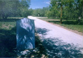
 At one time the state had installed several picnic tables on concrete slabs
throughout the small park, but these are gone now, except for the smattering
of concrete slabs. Several private residences are located near the site in
close enough proxcimity to detract from any feeling of being away from civilization.
After taking a few photos and enjoying the 100+ temperatures we headed back
to the relative coolness of the coast leaving Ft. Lipantitlán to continue
it's history as a forlorn outpost of Texas history.
At one time the state had installed several picnic tables on concrete slabs
throughout the small park, but these are gone now, except for the smattering
of concrete slabs. Several private residences are located near the site in
close enough proxcimity to detract from any feeling of being away from civilization.
After taking a few photos and enjoying the 100+ temperatures we headed back
to the relative coolness of the coast leaving Ft. Lipantitlán to continue
it's history as a forlorn outpost of Texas history.